Weather Services
We specialise in the protection of outdoor lone worker and remote working teams. Unique to Trackplot, we provide a comprehensive range of Weather and Environmental Services so you can keep your workers safe.

Situational awareness
Outdoor workers are exposed to multiple hazards including adverse weather conditions and environmental risks. Trackplot provides the following Weather Services to highlight potential dangers so you can minimise risk:
- Met Office Weather Warnings Service – UK-wide
- Flood Warnings and Alerts – across Great Britain
- Personal Severe Weather and Flood Notifications
- Environmental Mapping Service – UK-wide
- Individual Worker Weather Conditions
Available to Trackplot customers these services can be accessed 24/7/365 on the Trackplot Portal. This data helps you build situational awareness by assessing the current and forthcoming weather, flooding and environmental conditions you or your workers may find themselves in. The Notifications reinforce this data by warning workers personally when they could be in danger.
43% of people have been caught out unexpectedly by severe weather over the past year.
How will I use these services?
You can use the information to:
- Crisis manage a situation if a lone worker is caught in serious weather.
- Plan and schedule work according to your location and the local conditions.
- Review or cancel schedules which may put lives or property at risk.
- In the event of an “Overdue”, “Assistance Required” or “SOS” incident:
- Anticipate the type of accident that may have occurred.
- Assess lone worker vulnerability.
- Inform how you implement your Escalation Procedures.
Be weather ready. Check the latest forecast and know how to take action if needed.
1. Met Office Weather Warnings Service
To assess severe weather UK-wide.
Provides advance notice of forthcoming severe weather to minimise the loss of life and damage to property and infrastructure.
-
8 weather types
Rain, Thunderstorm, Wind, Snow, Lightning, Ice, Extreme Heat and Fog
-
Forecast up to seven days ahead of the expected severe weather
-
A clear description of the expected weather
-
A clear description of the potential impacts the weather may cause
e.g. travel delays or cancellations, power cuts, mobile phone coverage disruption, potential for injuries
-
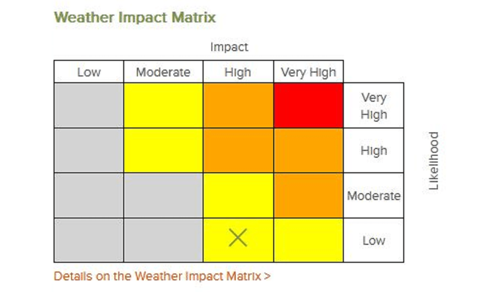
Weather Impact Matrix
Yellow, Amber or Red to indicate the level of impacts that may occur and the likelihood of those impacts occurring
-
Updates when the forecast is changing
-
Advice on what to do in severe weather
-
Which locations will be affected
In collaboration with the Met Office we provide our customers with weather warnings forecast up to 7 days ahead of the expected severe weather. Warnings can be issued for any one of eight different weather types.
READ MET OFFICE INSIGHTS ARTICLE: Met Office data helps Trackplot keep outdoor lone workers safe
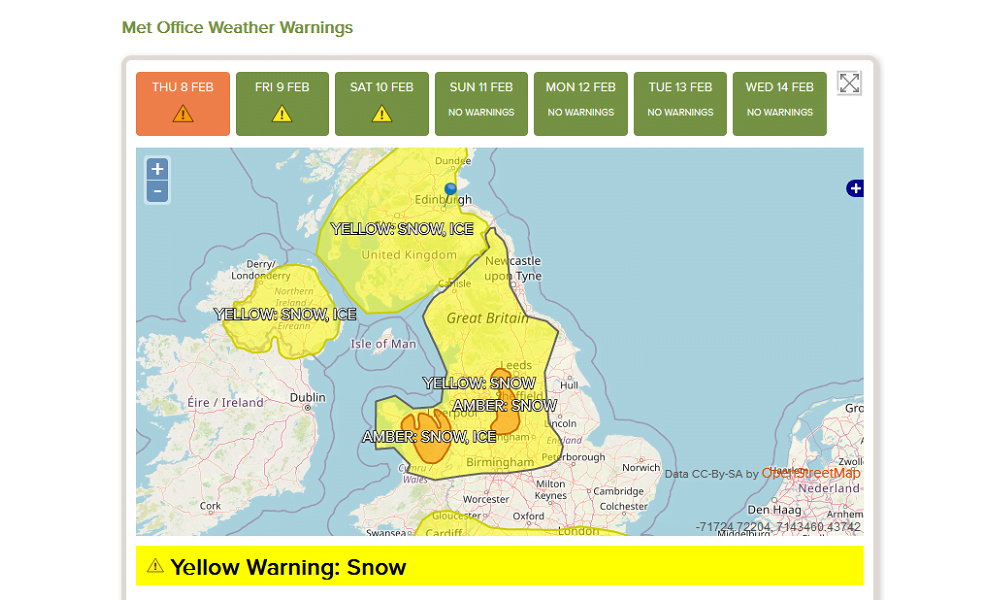
Amber and Yellow Severe Weather Warnings in Trackplot Portal.
Weather warnings are issued when the weather may be severe enough in nature to disrupt routines.
The geographical areas affected are coloured to indicate the warning severity, for example either a Yellow, Amber or Red Weather Warning, along with the specific weather type forecasted.
Consistent information is vital to minimise confusion and drive action to minimise the impacts of severe weather.
How to use the data
You can use this data to manage your business and lone workers, for example, hospital and ambulance services use weather information for the anticipation of different types of accidents such as:
- air pressure is linked to the number of heart attacks
- frosty weather to the number of slips, trips and falls resulting in hip replacements.
As a result, they can forecast the demand for ambulances and hospitals.
What are Met Office Weather Warnings
The National Severe Weather Warning Service (NSWWS), which delivers Met Office Weather Warnings, was established in 1988 as a result of the widespread impacts experienced during the Great Storm of October 1987. Following the introduction of the Civil Contingencies Act (2004) and consultation with emergency responders and members of the public, NSWWS developed to become a warning service based on the impact of the weather rather than a threshold of the weather itself.
The Met Office is recognised by UK government as the national weather warning service for the UK. The Met Office issues weather warnings to warn the public and emergency responders of impacts associated with severe or hazardous weather, which have the potential to cause disruption, damage to infrastructure or a danger to life.

Powered by Met Office data
2. Flood Warnings and Alerts
Live across Great Britain – this data is sourced from Environment Agency, SEPA and Natural Resources Wales. Available as maps in the Trackplot Portal, these live feeds helps you plan work, prepare for flooding events and respond appropriately if a worker is in trouble and needs help.
-
Red - Severe Flood Warnings
= Severe Flooding, Danger to Life.
-
Amber - Flood Warning
= Flooding is Expected, Immediate Action Required.
-
Yellow - Flood Alert
= Flooding is Possible, Be Prepared.
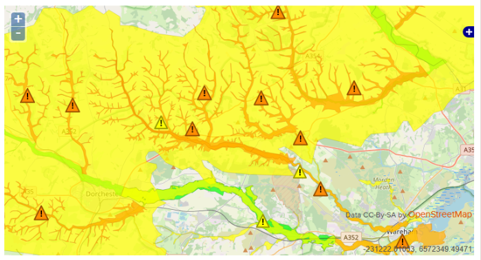
Amber Flood Warnings and Yellow Flood Alerts displayed in the Trackplot Portal.
READ THE ARTICLE: New Flood Warnings and Alerts for Scotland and Wales
3. Personal Severe Weather and Flood Notifications
These individual Notifications utilise the Met Office Weather Warnings data (UK wide) and the Flooding Warnings and Alerts data (England, Scotland and Wales) to alert a worker if they are in a severe weather or flood region. This notice enables the worker to reassess their schedule and decide on a contingency or whether to abort their mission. The Notification is also sent to the worker’s Notification Contacts so they are aware of the situation and can provide assistance if needed.
READ THE ARTICLE: Personal Severe Weather Notifications (UK) and Flooding England
Lone worker in an amber flood area who will receive a Personal Severe Weather Notification from the Trackplot Portal.
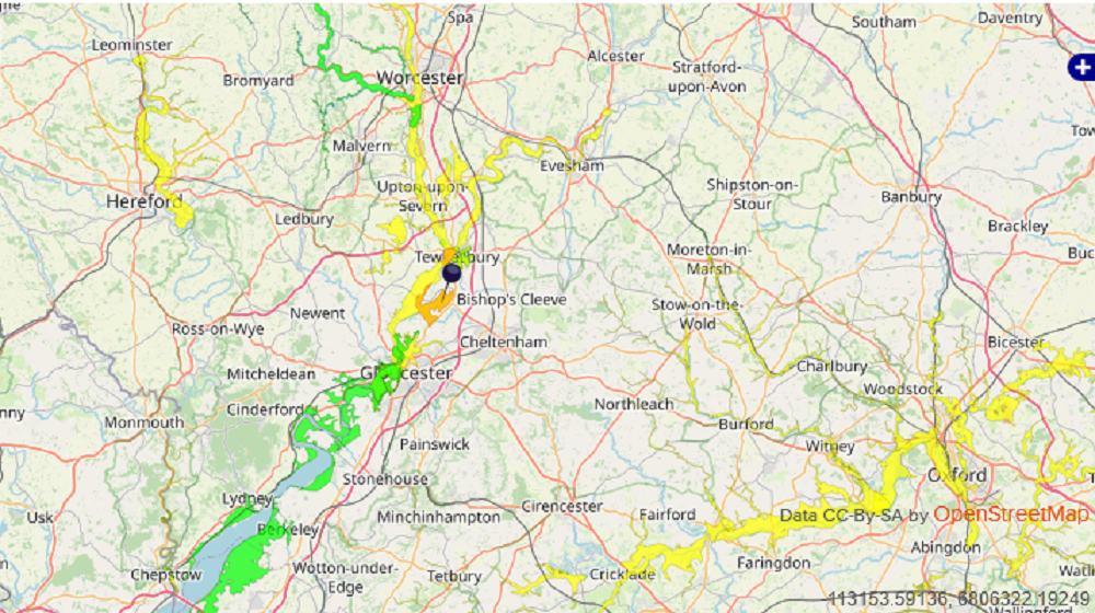
4. Environmental Mapping Service
To assess current conditions. The Trackplot Portal is integrated with a comprehensive series of real-time Environmental maps to help you assess the risks of weather conditions and environmental hazards:
-
Rain forecast
-
Temperature forecast
-
Wind forecast
-
Rapidly Developing Thunderstorms
-
Fire Weather Index
-
Active fires
These Environmental maps complement the Ordnance Survey mapping in the Trackplot Portal so you can determine the risks to lone workers of oncoming weather. Especially useful to assess lone worker vulnerability if there is an Overdue, Assistance Required or SOS incident.
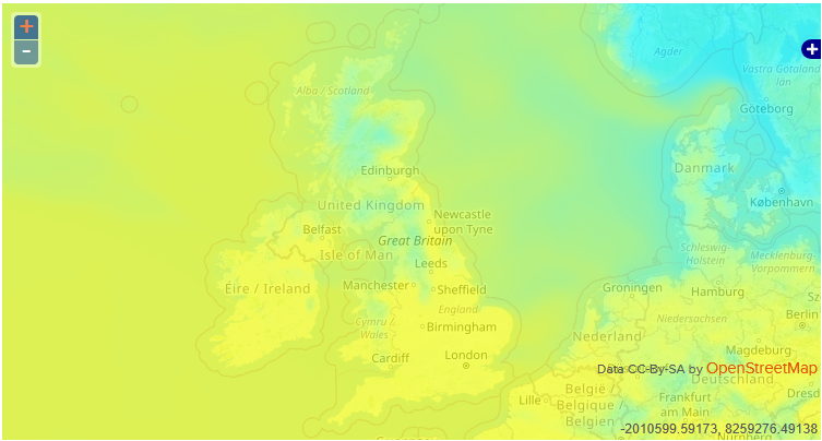
Example of Temperature Forecast displayed in the Trackplot Portal.
You can also use the maps to plan and schedule work according to your location and the local conditions.
5. Individual Lone Worker Weather Conditions
This service provides a range of specific weather data for an individual lone worker at their Last Known Position including Visibility; Temperature and Feels Like temperature, Wind direction and speed, UV Index.
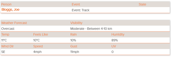
Example of individual worker weather conditions displayed in the Trackplot Portal.
Live data for individual worker locations from OpenWeather.
Weather, Flooding and Environmental data sources
Met Office Weather Warnings provided by the UK Met Office.
Flooding data provided by Environment Agency, Scottish Environment Protection Agency and Natural Resources Wales.
Environmental data is collated from various sources including OpenWeather, European Organisation for the Exploitation of Meteorological Satellites (EUMETSAT), European Forest Fire Information System.
Publications
Forestry Journal 2024: Trackplot’s storm warnings will protect lone forest workers