New functionality! Environmental mapping
Launch of comprehensive suite of real-time environmental maps to help you assess the risks of weather conditions and environmental hazards.
Trackplot launches a new comprehensive suite of real-time environmental maps to help you assess the risks of weather conditions and environmental hazards.
-
Rain forecast
-
Temperature forecast
-
Wind forecast
-
Fire Weather Index
-
Active fires
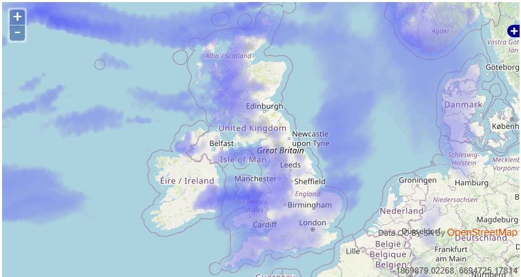
Example: Rain Forecast overlay in Trackplot Portal.
Benefits of environmental mapping
Lone and rural workers working outdoors are exposed to a wide range of risks including extreme weather conditions in both summer and winter and environmental threats such as wildfires.
Many of the workers using the Trackplot system work in remote areas. These new environmental maps overlay the accurate Ordnance Survey mapping in the Trackplot Portal so you can:
- Determine the risks to workers of oncoming weather.
- Assess worker vulnerability if there is an Overdue, Assistance Required or SOS incident.
- Plan and schedule work according to your location and the local conditions.
How to use Trackplot’s environmental maps
Here are a number of risk examples to illustrate which environmental maps to use and when to inform your decisions:
Summer working hazards
Heat stress: There is an increased risk of heat stress for outdoor workers during hot summer months. Wearing protective clothing and performing heavy work in hot and humid
conditions could also increase the risk. Heat stress symptoms will get worse the longer someone remains working in the same conditions.
Read more about heat stress.
MAPS TO USE: Temperature forecast, Wind forecast, Rain forecast.
UV rays: Sunburn is an additional threat for outdoor workers, particularly when exposed for long periods to sunlight.
MAPS TO USE: Temperature forecast, Wind forecast, Rain forecast.
Active fires including controlled burning and wildfires: Wildfires are very dangerous, spreading fast, changing direction, and threatening people, the environment, wildlife, livestock, domestic animals and property. As a lone worker make sure you have an escape plan for your safety in the event of a wildfire.
MAPS TO USE: Fire Weather Index, Active fires, Wind forecast, Temperature forecast, Rain forecast.
Winter working conditions
Slip, trip and fall accidents: Shorter daylight hours and harsher weather conditions directly affect outdoor workers particularly when there is ice or snow. During the winter season slip, trip and fall accidents increase.
MAPS TO USE: Temperature forecast, Rain forecast, Wind forecast.
Read our article on winter weather considerations.
Hypothermia: this is a dangerous drop in body temperature below 35C (normal body temperature is around 37C). It’s a medical emergency that needs to be treated in hospital.
Frostbite: this is damage to skin and tissue caused by exposure to freezing temperatures – typically any temperature below -0.5C (31F). Frostbite needs to be treated by a healthcare professional.
Read our article focusing on frostbite and hypothermia.
MAPS TO USE: Temperature forecast, Rain forecast, Wind forecast.